Brightspeed
"Meeting fiber deployment KPI's"
Craig Krammes, Director for IT Engineering Systems
単一のプラットフォームにより、急速に変化するグリッドに対応した企画および設計が可能な、柔軟で包括的な地理空間ソリューション
最適化されたデジタルツインで何でもモデリング
すべてを単一のネットワークビューに統合
オンラインでもオフラインでも、現場のどこからでも使用可能
電気業界は一世代に一度の変革(グリッドの近代化とネットゼロの脱炭素化イニシアチブ)に直面しています。 次世代ネットワークの展開にはスピードと敏捷性が必要ですが、従来の地理情報システム(GIS)では展開することができません。 IQGeo Network Manager ElectricTMは、電気ネットワーク事業のオペレーターが直面する新たな課題に最適に対応する、画期的な地理空間ソリューションです。 Network Managerの電気公益ソフトウェアは、業界で最も機敏でオープンなソリューションを提供し、建設および保守作業を通じてネットワークライフサイクル全体をサポートしながら計画と設計を加速します。
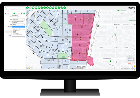
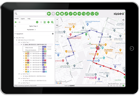
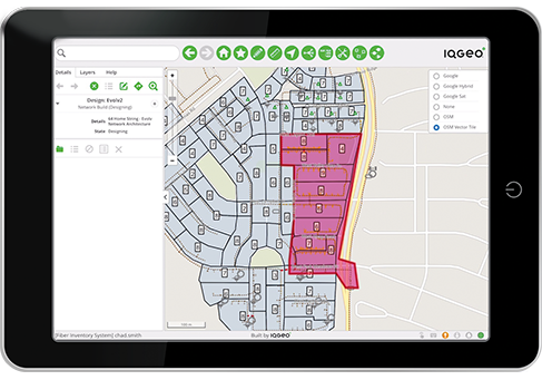
すべての設備データと位置情報を単一の地理空間ビューに統合し、チームがワークフロー内で簡単にコラボレーションし、障害とビジネスチャンスを積極的に特定できるようにします。
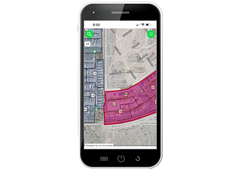
電気公益事業の現場チームが、オンラインまたはオフラインでリアルタイムにデータを識別および文書化して、データ品質を効率的かつ柔軟に改善できるようにします。
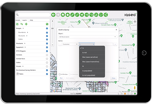
すべてのデータソースおよび内部システムと簡単に統合できる事前にパッケージ化されたワークフローと柔軟な構成で収益を得るまでの時間を短縮できます。
導入率を高め、すべてのチームが一貫してこのインターフェイスを利用することで作業を最適化します。
将来のネットワークモデル、新しい規制、気候変動への対応、進化するテクノロジー、変化するデータニーズをサポートできるように拡張することができます。
Network Managerの電気公益ソフトウェアは、運用マネージャーや建設プロジェクトリーダーからオフィスにいる設計者や現場エンジニアまで、すべてのチームにネットワークの真のシングルソースを提供します。 Network Manager Electricは、すべてのデータとアプリケーションを合理的に単一の地理空間ビューで表示し、電気公益事業ネットワークオペレーターが野心的な目標(グリッドの近代化)を達成するためのシステム・オブ・アクションを作成します。
データフィード – このソフトウェアは、Google、Bing、Here、OSM、天気、政府の分析など、すべての電気公益事業のデータを統合します。
GIS統合 – GISにとらわれないアプローチにより、Esri、GE、Intergraph、Bentley、SpatialNet、Mapinfo、3-GIS、IQGeo、OSPIなどを簡単に統合できます。
現場ビューとキャプチャ – レッドライニング、現況の詳細、写真、ビデオセンサー、ドローン、VR、ARなどを簡単に組み込むことができます。
アプリケーション統合 – Maximo、Salesforce、SAPからNetcracker、Nimble This、OSS、BSSなど、すべての電気ネットワークアプリを単一の地理空間ビューに統合できます。
With over 50,000 active software users, IQGeo has an established and rapidly growing customer base with telecoms and utility companies worldwide. Hear directly from our customers about how IQGeo is helping them to accelerate productivity and collaboration across their business.
Jeffrey Cito, Project Manager Operations - ECMC
Amy Grice, Manager of System Engineering & Operational Technologies
IQGeo has the agility that we were looking for as well as the leadership in this space and I think those two factors sealed the deal for us. We knew that we would be in good hands.
The IQGeo team immediately understood our challenges and delivered a presentation and Proof of Concept that addressed our biggest concerns. We continue to be impressed by both the team and the software, which has exceeded our initial expectations. Offline support, validating designs and version control were causing us major headaches. Thanks to IQGeo, these are now problems of the past!
We are pleased to be working with IQGeo and are already very impressed with the capabilities of the IQGeo Platform.
IQGeo gives us a simple tool to assist with network planning and auditing that is easy-to-use in the field. Over the 40 plus years that I have spent in the field, I have never found a solution that can do this, not until I found IQGeo.
It’s a real pleasure working with the team at IQGeo who exceed expectations in everything that they deliver to us. They work closely with us to understand potential application development whether it be for wires down response, meter reading or collection activity in the future. As a utility, the ability to have communications with an organization that listens and develops and tests with you is amazing.
We’ve been very impressed with IQGeo, the team has worked incredibly quickly and been able to cater for our specific business and technical requirements.
IQGeo Inspection & Survey makes it lightning fast to create a survey definition and push out to a survey tech in the field. I am excited about our continued partnership.
The advantages of putting powerful, but easy-to-use Inventory Maps into the hands of the right staff are tremendous.
When you first see the IQGeo Platform it’s a real eye opener. It’s modern looking and easy-to-use with a simple user interface, unlike any other geospatial system. As an electric cooperative, we’re committed to technology advancements that improve service for our members, safety, system reliability and employee relations. IQGeo helps us to tick a lot of these customer satisfaction boxes.
Unlike legacy GIS that use a centralized, process-heavy architecture dependent on highly specialized engineering resources, IQGeo empowers field and office staff to easily monitor, capture, visualize and manage geospatial network assets without specialized training. We deliver an end-to-end solution with measurable ROI that increases productivity and collaboration across the entire organization.
Did you know that an automated fiber planning process can reduce your design times by up to 90% and integrating construction workflows can save up to 10% on your build costs? Watch the webinar to learn more about the benefits of an integrated planning, design, and construction process.
Watch nowCopyright © 2022, IQGeo UK Limited. IQGeo is a registered ® trademark