Ground truth, the degree to which an operator’s physical network records match what is actually in the ground, is becoming a defining issue for the telecom industry.
As telecom operators invest in automation, AI and autonomous network operations, every decision those systems make is only as reliable as the physical network data underneath. Where cables run, what connects to what, which ducts are occupied: if that data is wrong, the systems acting on it will produce wrong outcomes, too, with considerable repercussions for service delivery.
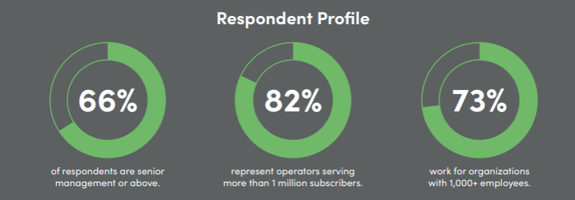
The industry has long known that its physical network data is not accurate enough, but the scale of the problem has not been quantified. IQGeo commissioned Vanson Bourne, an independent technology research firm, to measure the data gap and assess its consequences for network operations, autonomy readiness, sustainability and more. They surveyed 500 telecom decision-makers across the United States, Canada and the United Kingdom, two-thirds of them in senior management or the boardroom. Representing mobile, fixed broadband, fiber, integrated and wholesale operators, these leaders oversee many of the industry’s largest networks.
Operators have committed to autonomous networks, with most expecting to reach full autonomy before 2030. The journey is underway, but organizations recognize there are still operational challenges to overcome.
57% of organizations with 1,000+ employees expect to be ready before 2030, compared with 40% of smaller organizations.
51% of operators serving fewer than 1M subscribers expect readiness to come 2030 or later, compared with 33% of operators serving 1M+ subscribers.
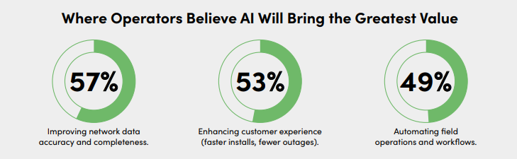
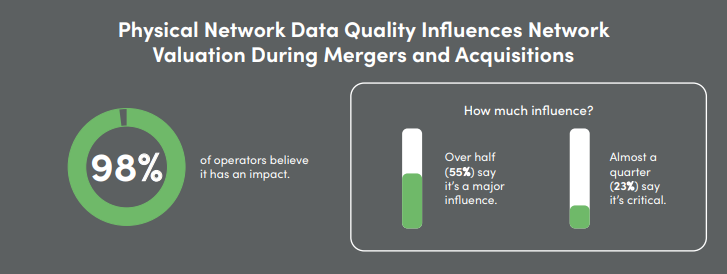
The research shows that most operators are still struggling with data quality, with business impacts felt across the organization.
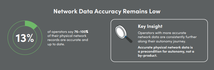
Regardless of organization size, geography or system type, working with inaccurate or outdated network data contributes to issues such as:
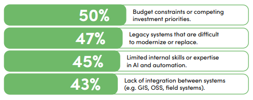
The most commonly cited caused include:
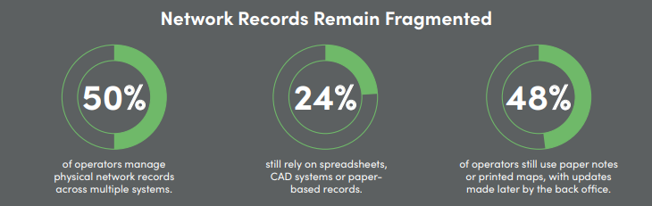
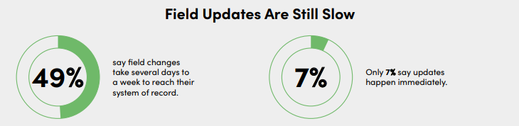
Fragmented systems, manual processes and aging technology continue to slow the flow of accurate network data.
 Key Insight
Operators using a single integrated geospatial system report a faster update of their system of records (4.5 days), compared to operators using multiple systems (5.3 days).
The average age of operators’ current network management software is 13 years.
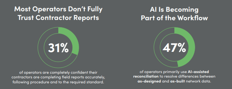
Operators are capturing more field data, but validating it consistently and using it to keep network records up to date remains a challenge.
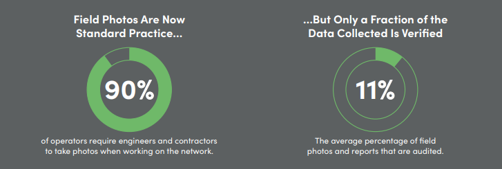
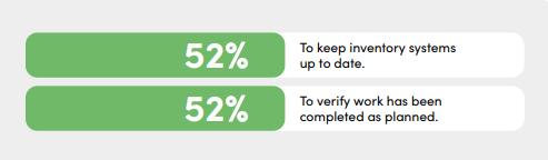
Key InsightOperators use a wide variety of approaches to audit field photos. While most still rely on some form of manual review, AI-enabled photo capture and analysis is now the most widely used method (58%). Adoption is highest in the UK (72%) and Canada (71%), but just 45% in the US.
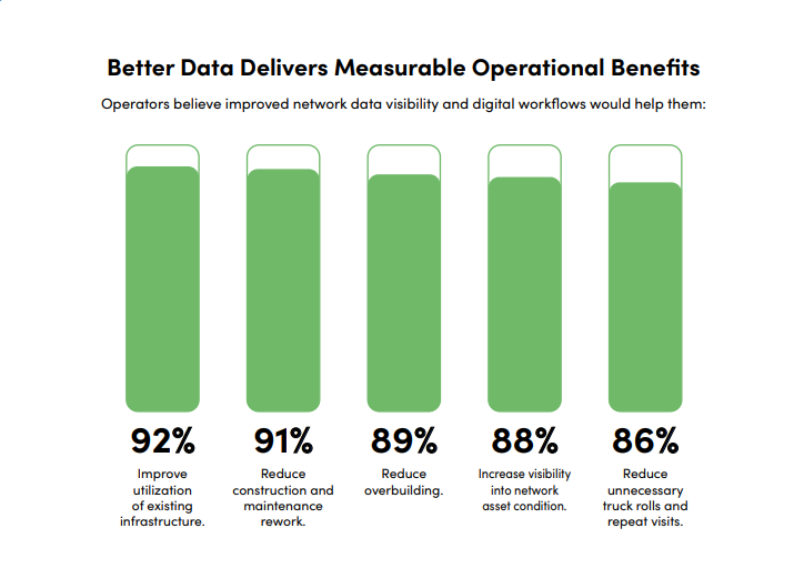
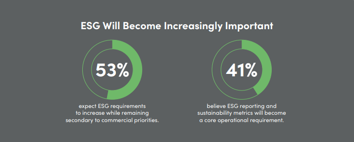
Operators increasingly see accurate network data and digital workflows as essential for improving operational efficiency while supporting sustainability objectives.
Register for our webinar on October 21st for a deep dive into what the findings mean for the industry with leaders from across global network operators.

In this panel discussion, senior telecom leaders from Brightspeed and Swisscom join IQGeo CTO David Cottingham to examine the survey findings and share their own experience of the challenges they reveal.
Download the full report for every survey question, complete data tables and the respondent profile.