Network infrastructure providers in both telecoms and utility markets worldwide are undergoing a period of profound change. For telecoms, highly competitive markets and new technology such as FTTx and 5G are all creating new opportunities for revenue, but at the same time major challenges in terms of time to market and managing legacy technology. In the utility markets new technology such as smart meters, IoT and smart networks demand significant investments into networks that must be combined with ever increasing regulatory standards on safety and security.
While the technology and day to day challenges have evolved significantly over the last 20 years for both telecoms and utility network operators, operational systems for designing, building and maintaining these systems in the market have not kept pace. Many operators find themselves planning these new networks on the same systems as they used decades ago.
At IQGeo we see things differently. We see five key trends that are fundamentally changing the way enterprises use technology within their organisations to design, build and manage networks.
1. Next generation networks will need a reality-centric geospatial approach
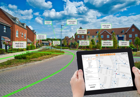
Telecoms and utilities networks are increasingly complex, with thousands of constantly changing assets across miles of infrastructure. However, the cartography-centric approach of traditional GIS makes the effective management of these networks almost impossible.
Cartography-centric systems were designed for the needs of traditional mapmakers and were built around the concept of very few specialised users designing and printing maps for the rest of the organisation. Today it’s simply no longer workable to rely on a technology that was built around the needs of a small group of virtuoso users. No organisation today would accept the concept of a ‘typing pool’ typical of large organisations from the 50s to the 70s. So why should companies accept the concept of a ‘geospatial pool’ today? The answer is because cartography-centric systems offer no alternative.
A reality-centric approach is different because it’s built around the needs of network operators, not GIS experts. A reality-centric approach understands that a network is an assembly of thousands of live components that must be designed, built and serviced by large workforces of many different types of users. Reality-centric systems produce a digital twin of the network that can be viewed and worked on by all departments that touch the network lifecycle. A reality-centric geospatial system creates is a living, breathing digital twin of the network that gives the right information to all users in any location, at any time. Paper is dead. Long live digital twins.
2. Network operators will become big data experts
High quality data and real-time, or near real-time, data currency is essential to the management of rapidly evolving digital networks. Deploying next generation networks requires enterprises to harness and manage huge amounts of data. This means that telecoms and utility network operations companies will transform into data intensive businesses in the same way that Google or Facebook today analyse their data.
In order to become big data experts, they must collect data in the field where their networks are in a constant state of change. This demands the use of tightly integrated mobile tools and passive data gathering technology like IoT sensors and smart meters. The emerging role of Chief Data Officer will be responsible for finding previously hidden correlations between many different activities and sharing these insights to transform the organization. The benefits can be truly game changing, with dramatically improved productivity and safety, while cutting operating cost and delivering better customer service.
In the future, data management will become an existential problem for network operators. The telecoms and utility companies that master the art of enterprise data management first will thrive. Those who don’t will get smoked. Don’t say we didn’t warn you.
3. Systems and processes will become human-centric
As consumers we expect software experiences that are built around us. Does anyone miss the days when driving cross country involved a marked-up, half torn, paper map strewn across the dashboard? Today’s intuitive mapping applications have banished arguments about missed exits because they are based on an understanding of observed human needs and are built to respond to these needs. Gone are the days when people were forced to change their fundamental behaviour to adapt to processes defined by a software application. The most successful software is designed around observing us as a species.
Today’s most successful enterprise software is also following this trend, moving away from systems and processes that can only be used by a few, highly skilled individuals. Relying on technology that is inherently complex to use will not achieve the transformation in behaviours organisations need to succeed. How many enterprise initiatives have stalled because users ‘don’t like’ the software and revert to old methods or introduce local workarounds? I can think of quite a few.
Human-centric systems are different because they understand the link between adoption and transformation. If a system is human-centric it will get used widely across an organisation. If a system gets used, it can drive new forms of behaviour that will lead to improved processes, increased collaboration, greater transformation. For enterprise software, human-centric actually becomes business-centric.
One more thing. Human-centric systems will also help you hold on to those millennial employees we all spend so much time worrying about. They really hate bad software.
4. Field operations must become fully digital
Here in the UK a large construction company recently had their contract cancelled because they lost copies of the plans to the building they were refurbishing. It just so happens that building belonged to MI5. You read that right. They lost the plans to 007’s headquarters. That is what happens when you don’t digitise field operations and you rely on good old-fashioned paper and crossed fingers. You can be certain that this particular construction company regretted not investing in a digital operations solution.
For network operators to have an accurate view of operations and assets, it’s essential that staff and contractors working in the field are fully digital. They must have the latest information at their fingertips and be easily able to update back office systems to reflect realities on the ground. At the same time the enterprise must be able to control who sees what and which rights they have with data. With the correct software, the powerful computing capabilities of smartphones and tablets make this both possible and practical.
While all geospatial systems will claim to have mobile capabilities, they are mostly bolt-on afterthoughts that are subordinate to a centralized, legacy GIS. Full field digitalization can only be achieved with a different architectural approach that puts mobile on an equal technical footing with office staff. This new approach is the best way to ensure data is accurate and current. It enables greater efficiency across maintenance and construction activities and provides the ability to proactively manage emergencies and natural disasters, potentially saving lives and certainly avoiding lost plans to secret service buildings.
5. Operations will be increasingly customer-centric
If you don’t please your customers, your competitors will. They don’t just expect good service, they also insist on transparent and honest interactions. To monitor customer satisfaction operators are increasingly including metrics like Net Promoter Score (NPS) as part of a broader set of corporate KPIs. Up to now NPS has been used extensively at the retail end of the business. However, NPS is increasingly being used to drive operational priorities to manage customer churn and maximize revenue, as well as tracking regulatory and safety requirements. Why? Because everybody can sell a sweet deal to get a customer on board in year one, but not everybody can give that customer quality service that stops them looking for the next bargain in year two.
Within many organizations NPS will become part of a closed loop, data-driven analysis that directly connects customer loyalty with other operational KPIs. Operators will be able to directly measure customer churn against outages and interruptions. They will also be able to measure the impact on NPS of greater productivity on key activities like faster repair times and higher value services that help to increase revenue per customer. Network operators that focus on NPS develop a more holistic view of their business and understand the strategic role that digital transformation of the entire company plays in the ultimate success of the business. Putting the customer first should not be a slogan but a transformation strategy across the whole enterprise.
Calling all change-makers
At IQGeo we are good at what we do, but we are not prophets. The reason we can make these five predictions is because they are already happening today. Everything described here is happening (and working) somewhere today in our customer base. Our job is to enable all our customers to benefit from the insights we see and our experience of what is working well in our market.
For this reason, these five trends are also at the heart of what IQGeo is doing with our own market strategy and software development roadmap.
- Reality-centric:
IQGeo’s reality-centric approach reimages the role that geospatial software plans within your organization by streamlining complex, legacy GIS processes to dramatically improving operational productivity by providing the entire enterprise with a geospatially enabled digital twin of the network. - Big data: We help you capitalize on the opportunity presented by big data with an open geospatial platform that provides a single source of truth using a wide range of easily integrated data sources that give you new insights and new solutions for your business.
- Human-centric: Usability is a fundamental design principle for all our software, embracing a human-centric approach that accelerates adoption, collaboration and operational efficiency. We take care of the 1% of virtuoso users that need a specialised tool and the 99% of users that need access to geospatial network data.
- Digital field operations: Enabling the field is the foundation of our mobile-first product strategy. We turn legacy GIS architecture on its head, providing a decentralized mobile approach that empowers field crews to capture, visualize and manage network assets.
- Customer-centric: IQGeo delivers an end-to-end enterprise solution that allows you to monitor and manage your entire customer-centric ecosystem in order to drive higher NPS and deliver on your broader corporate KPIs.
The next decade will bring tremendous opportunities and challenges. Success will come to those that put their strategy in the hands of change-makers. Recognizing the macro trends that are already in motion and seeking out technology partners that share your vision will help to ensure that change-makers prepare your organisation for the challenges that lie ahead.
If you are a change-maker and you want to know how you can transform your organisation with enterprise geospatial tools that work, then let’s talk. We’ve got your back.
Download IQGeo's latest eBook to find out how network providers are navigating their digital transformation in an increasingly customer-centric business landscape.

 Previous